Africa: Political & Geographic Colored Maps
By TurboSquidOne great value subscription from $16.50/month
- Unlimited downloads of 27+ million creative assets
- AI Tools: video, image and more
- Lifetime commercial license
- Easy cancellation
Already have an account? Sign in
Attributes
- File Types
- MTL, PNG, OBJ, FBX
- File Size
- 61 MB
- Textures Included
- Yes
- Rigged
- No
- Animated
- No
- Polycount
- 75.1K polygons
- Commercial License
- Further Information
Description
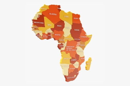
This rendering displays two contrasting depictions of the African continent. On one side, the map showcases the continent's political divisions, with each country distinctly colored and labeled. The color scheme varies from yellows and oranges to reds. On the other side, the continent presents a geographic representation of its terrain. Topographical details, including deserts, rivers, and mountain ranges, are visible. This map uses varied green, brown and arid color schemes that highlight the terrain and natural features. Coastlines and borders are clearly marked, facilitating easy identification of both countries and physical landmarks.